|
|
|
|
|
Survey Tools Technical Parameters A small exploration story
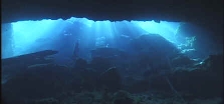
Update 2010Agnes Milowka and James Toland connected Peacock I to Baptizing Spring in August 2010 making it the 13th longest cave in the world at 6.5 miles of passage. A detailed story of the exploration is here: http://www.agnesmilowka.com/2010-november/107-peacock-springs-connection.html Update 2005-2006New survey was collected in the Martz offshoot, a sidemount passage that pinches off into no mount branching passages with discernable flow and sand floors. The new survey was incorporated into newer versions of the Peacock I map that have been available for several months. Yea to the State of Florida for purchasing lands described as being in the optimal boundary for the Peacock Spring system! The Martz passage and several other passages in the Peacock system head north towards land recently purchased by the State (across the road from the main part of the park and past Challenge Sink). While the land has been rough cleared, many large oaks are still standing and native growth is quickly reclaiming the area. More than 600 acres surrounds several very tiny seeps and springs that contribute to the Peacock System. This area is extremely important to the history of the State, being also the site of the earliest established mission in the state (Political and Economic Interactions Between Spaniards and indians: Archaeological and Ethnohistorical Perspectives of the Mission System in Florida, Jill Loucks, 1979 and personal correspondence with Dr. Jerald Milanich, 2005). Peacock Springs Mapping ProjectThe Peacock Springs Project was originally started by Steve Gerrard in 1991 with the purpose to re-map the system to a grade 5 accuracy. Since Peacock Springs is one of the most popular springs in Florida and is used extensively for training, Steve was also looking for a more detailed map as a training aid. The existing map just didn't have the detail to really show someone, who was unfamiliar with the system, what to look for and where the landmarks were. So the project got rolling in the summer of 1991 with one team surveying towards Pothole and Olsen sink and the other surveying the Peanut Tunnel. A start was made on mapping the surface features and tying all the sinks together on land. I joined the project in August of 1991 and by then the first rush of enthusiasm was gone. About half of the original group dropped out at that time and for a while it was just Tony Pate, Dennis Holden and myself. Dennis was the only one who had previous survey experience and was, for a while, taking all the data and plotting the map out on graph paper. So we began surveying the system as time permitted, Dennis and Tony were the most dedicated of the group and were up almost every weekend. In December of 1991, Scott Worrell joined our group and began helping on a regular basis. We realized fairly quickly that the grade 5 survey was out of the question. We used a fiberglass tape for all distance measurements, so we had accuracy there, but we found that consistently obtaining compass readings, within the accuracy demanded for grade five, was beyond our ability. In addition, the line was not always placed with survey in mind. For instance, there are many places where the line follows a curve in the wall, which is difficult to survey accurately without pulling the curve out of the line to get a straight line to survey. In the interest of time and logistics, we decided it was not practical try and eliminate all the sources of inaccuracies. Instead, we decided it was more important to add the explored, but not surveyed tunnels, and to do accurate sketches so that divers could more accurately determine where they were in the cave. To mark our stations, we used Plexiglas squares with numbers written in permanent marker. A hole was drilled in one end and a plastic cable tie was used to fasten the marker to the line. These were used to mark all the stations on the main (gold) line in the system. As we progressed to the side passages, particularly the smaller ones, we usually did not mark the stations. This was done to eliminate a second trip to remove the markers. We surveyed the main lines using a three or four man team, usually with Tony in front setting stations, Scott with the end of the tape behind him, and myself and Dennis taking up the rear. One of us would hold the tape and the other took compass readings and recorded the data on a slate. With a three man team, the guy in front set markers and held the tape. As we progressed to the smaller passages, we used a two-man team. The lead diver recorded depths and compass readings while holding the dummy end of the tape and the other diver operated the tape and recorded the distances. We kept a working drawing of the map at Spring Systems (now the Dive Outpost) which had all the stations marked on it. We would often hear divers commenting that "Hey, there's station so and so, that's were we were". Comments like these and the many positive comments we got from others divers we met at the springs are what kept us going on this project. In the first year and a half we tied all the major sinks together and had logged about fifty survey dives on the project. Unfortunately, that same year, Dennis began having health problems and he was able to dive less and less. He eventually had to leave the project. That summer, our leader, Steve Gerrard, relocated to Mexico, but still gave us moral support. That left Tony, and myself, with occasional help from Scott as the survey team. In January of 1993, Peacock Springs flooded and for the next six months went back and forth between clearing and re-flooding. Steve had said at the beginning that we would have ups and downs and that we should "Keep the Faith" and we would eventually finish the project. Well, this was definitely a down time for us. Between the floods and family considerations, it was May of 1994 before we really got back to surveying Peacock. In that 17-month period, we only logged five survey dives at Peacock Springs. In May of 1994, things began progressing fairly rapidly as our schedules allowed us to dive on a fairly regular basis. We made substantial progress despite there only being two of us surveying. By the summer of 1995 we had surveyed and sketched almost all the passage shown on the original map and we were ready to start surveying the areas shown as dotted lines. We also began looking at diving sidemounts to get at some of the smaller areas in Peacock. At this time, Bill Rennaker began helping us with the survey. Bill is an accomplished sidemount diver and was able to provide much of the data in the smaller passages. Dive-Rite also donated the use of two Trans-Pacs to aid in the survey and exploration of these areas. This was an exciting time for us. We had a lot of fun up until now, but we always knew what to expect, which was good because we were able to spot errors fairly quickly by referring to the existing map. Now it was almost like discovering virgin cave as we saw the map grow with previously un-surveyed passage. As it stands right now there is 22,487 feet of surveyed passage in Peacock. The old map had 19,020. Comparing these figures is a little misleading since we believe that the original length was determined by a different method than the one we use. The usual practice is to exclude those survey shots that go across surveyed passage. It doesn't sound like much, but it can add up pretty quickly. When we reached the point that we had everything surveyed that was on the old map, our passage length was 17,492 feet, with about 18,721 feet of survey. This leads us to believe the old map simply used total line length to get passage length. Since then, we have added an additional 5,100 feet of surveyed passage to the system, with total survey distance of 23,820 feet and passage length of 22,487 feet. January of 1996 marked the end of the Peacock I survey project. There are still some sidemount leads left to explore and map, but we feel we have surveyed everything that most divers will ever see. We hope to have the new map available in a 1:100 scale map (24" X 36") at the CDS workshop on May 25-26. A survey of Peacock III is underway and we have about 5000 feet of survey completed thus far. We would like to thank the following for their help in this project: The Florida Park Service for allowing us to dive, and in particular Joe Mcgrath and Richard for their help and support, Spring Systems - The Dive Outpost and Cave Excursions for air fills and lodging, American Underwater Lighting for survey markers, Terrence Tysall for the use of his sonar gun, Jerry Johnson and the Florida Speleological Society for the use of their SMAPS program, and to Dive-Rite Manufacturing for survey line and Transpacs.

Copyright © 2001-2025 |